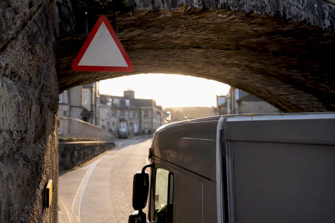
The design-standard headroom for new trunk roads and motorways in Great Britain is 5.03 metres (16 ft 6 in), but that figure is a construction reference, not a guarantee at every structure. Bridges signed below roughly 4.95 m (16 ft 3 in) carry mandatory height roundels that make it unlawful to pass if your vehicle exceeds the stated limit. The one action that matters most: know your exact travelling height, including any load or roof equipment, and cross-check your route against validated low-bridge data before you set off using diagnostics and fleet checks.
TL;DR:
- Drivers must verify their vehicle's exact height, including any load or roof equipment, and cross-check routes against validated low-bridge data before departure.
- Official datasets and community maps should be combined to ensure comprehensive, up-to-date information on low-clearance structures, especially on older or temporary bridges.
- Mandatory signs below approximately 4.95 meters legally prohibit passage for taller vehicles, with actual clearance often being lower on older or arch bridges.
- Approach arch bridges cautiously by slowing down, staying within the central safe zone marked by goal posts, and not relying on guesswork for lateral positioning.
- Route planning should incorporate clearance checks into operational procedures, using specialized tools rather than consumer sat navs to prevent bridge strikes.
Table of Contents
- Where to get validated low-bridge data and maps in the UK
- What do UK low bridge warning signs actually mean?
- How are bridge clearances measured, and why do arch bridges catch drivers out?
- Practical route planning and bridge-strike prevention for drivers
- Which tools should you actually use: datasets, maps, or APIs?
- What to do if you hit or witness a bridge strike
- Why clearance checks belong in every logistics operation
- How Sddbyaba handles route-sensitive, time-critical deliveries for you
- Sources
- FAQ
Where to get validated low-bridge data and maps in the UK
Guesswork has no place in route planning for a vehicle over 3 metres tall. The most authoritative starting point is the government's own Location of bridges with a height restriction dataset on data.gov.uk, which lists geolocated structures with recorded clearance limits. Network Rail also holds public records tied to its bridge-strike monitoring work, useful for cross-referencing rail-owned structures specifically.
Beyond official records, specialist driver-facing tools fill practical gaps that raw datasets leave open:
- Direction-aware low-clearance maps, such as Low Clearance Map, which validate entries against user reports and flag hazards only when you're approaching the low side of a bridge.
- Commercial routing APIs built for fleet software, letting operations teams check a whole day's jobs against known restrictions in one pass.
- Community-reported updates, which matter because official datasets update on fixed cycles and rarely capture every minor-road structure or temporary works.
No single source covers everything. Combining the dataset with a specialist map gives you both authority and day-to-day practicality.
What do UK low bridge warning signs actually mean?
The 5.03 m figure gets quoted often, but it only applies as a design target for new trunk road and motorway structures. Plenty of older bridges, particularly on A roads and in town centres, sit well below it. That's why the signing threshold matters more for everyday driving.
Bridges are typically signed once clearance drops below about 4.95 m (16 ft 3 in), according to Gov.uk's traffic signs guidance. Below that height, authorities install a specific sign type with real legal weight.
The two sign shapes you'll encounter mean very different things:
- Circular sign with a red border showing a height in metres and feet: this is a mandatory, prohibitory sign. If your vehicle exceeds the stated height, passing underneath is against the law, not just inadvisable.
- Triangular warning sign: this flags a hazard ahead, often on approach roads before the mandatory sign itself, giving you distance to react or divert.
Treat the roundel as a hard stop, not a suggestion. Drivers sometimes assume a few centimetres of margin exists in the stated figure. It doesn't. The number on the sign is the maximum, not a rounded-down estimate with wiggle room built in.
Pro Tip: If you're relying on a consumer sat nav that shows a low bridge warning triangle rather than a specific numeric limit, treat it as incomplete information and check the actual signed height on approach.
How are bridge clearances measured, and why do arch bridges catch drivers out?
Nominal clearance figures come from a physical measurement at the point of least headroom, but several things can erode that margin over time. Resurfacing is the most common culprit: when a road gets a new layer of asphalt, the road level rises and the effective clearance can shrink by several centimetres without the sign being updated immediately. Suspension setup and load distribution on your own vehicle can shift your actual height too, particularly on vans with roof racks or extended load bodies.
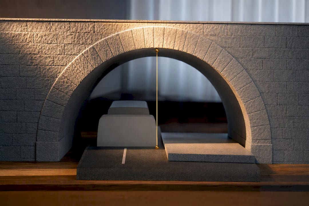
Arch bridges bring a specific complication. Because the arch curves, full height is only available across a narrow central band, commonly around 3 metres wide. Move towards the edges and headroom drops fast, which is why many arch structures carry "goal post" markings, painted or physical barriers set at the edges of the safe central path.
Key points to keep in mind before you approach one:
- The signed height applies only within the marked central zone, not edge to edge.
- Goal posts exist to guide lateral position, not just to warn of low clearance.
- Recent roadworks or resurfacing notices are a reason to re-verify a route you've driven before.
Pro Tip: If you can't see goal-post markings clearly on approach to an arch bridge, slow right down and position centrally rather than guessing where the safe band starts and ends.
Practical route planning and bridge-strike prevention for drivers
A bridge strike happens roughly once every five hours somewhere in Britain, and the pattern behind most of them is depressingly simple: a driver didn't know their vehicle's true height, or didn't check the route properly beforehand. Building a habit around three stages closes that gap.
- Before you drive: confirm your vehicle's travelling height with any load, roof equipment, or pallet stacking accounted for, then display that figure somewhere visible in the cab. Cross-check your planned route against a validated dataset or specialist low-clearance map rather than assuming a consumer sat nav has flagged every restriction.
- On the road: obey every height sign without exception, slow down well ahead of arch bridges, and follow goal-post markings precisely rather than eyeballing the centre. If a diversion forces you off your planned route, stop and re-check clearance data before continuing rather than pressing on and hoping.
- Within the operation: build clearance checks into every job brief, not just the ones that look obviously tall. Choosing between a van, a 7.5-tonne truck, or an 18-tonne vehicle for a given route should factor in known restrictions on that corridor, not just payload.
Pro Tip: Never let a driver rely solely on a phone-mounted consumer sat nav for HGV routing. Those apps are built for cars and routinely miss or misjudge low bridges that specialist tools flag correctly.
Fleet managers running mixed vehicle types should also review axle weight limits alongside height restrictions, since routes with tight clearances often carry weight limits on the same structures.
Which tools should you actually use: datasets, maps, or APIs?
Three categories of tool cover different needs, and picking the wrong one for the job is a common mistake.
- Official datasets and Network Rail records give you the most authoritative baseline figures, ideal for verifying a specific structure or building your own reference list, but they're not designed for turn-by-turn routing.
- Specialist driver-facing maps, like Low Clearance Map, add the routing layer: direction-aware alerts, verified community entries, and practical warnings pitched at drivers rather than analysts.
- Commercial APIs and CSV feeds suit fleet-level integration, where clearance checks need to run automatically against every job booked, not just the ones a dispatcher remembers to check manually.
When evaluating any tool, ask four questions: how wide is its coverage, how often does it update, how are entries verified, and does it distinguish direction of travel. A tool that warns you regardless of which way you're heading generates false alarms that drivers start to ignore, which defeats the purpose entirely.
What to do if you hit or witness a bridge strike
A strike demands calm, ordered action, not panic.
- Stop safely and make the scene secure. Switch on hazard lights, check for injuries, and warn approaching traffic if it's safe to do so.
- Report it immediately. Call emergency services if anyone is hurt or the structure looks compromised, then notify Network Rail or the relevant local highways authority so the bridge can be inspected before further traffic passes.
- Document everything. Photograph the vehicle, the bridge, and the sign that was in place, and note the time and any diversion that led you there.
The consequences for an operator go well beyond the immediate repair bill. Rail-owned structures trigger formal investigation, network disruption can run into hours or days of delay for passenger and freight services, and prosecution is a real possibility where a driver ignored a mandatory sign.
Why clearance checks belong in every logistics operation
Route-sensitive planning isn't a paperwork exercise. When we're briefing drivers on a job that involves height-restricted corridors, the vehicle choice gets decided before the route does. A tight urban run might rule out anything above a Luton van; a longer haul with awkward rural bridges might push us toward a smaller rigid instead of an artic, even if that means splitting a load. Getting that decision wrong doesn't just risk a strike. It risks the job.
— Ayomide
How Sddbyaba handles route-sensitive, time-critical deliveries for you
You can choose a service that builds clearance checks into job planning before a vehicle ever leaves the yard, so you're not left cross-referencing sat navs against government datasets on a tight deadline.
We run a full range of vehicles, from motorcycles and small vans through to 7.5 tonne, 18 tonne, and 26 tonne trucks, which means we can match the vehicle to the route rather than forcing a route to fit whatever's available. That matters when a job involves rural bridges, town-centre arches, or a corridor with known restrictions. Drivers get briefed on route-specific clearance risks as standard, and our freight haulage team keeps contingency options ready for diversions.
If your next consignment needs a vehicle chosen with clearance in mind rather than guessed at, request a quote from Sddbyaba and talk to our operations desk about the route before you book.
Sources
- Low bridge signs
- Preventing bridge strikes (Network Rail)
- Location of bridges with a height restriction - Dataset
- Prevention of bridge strikes - A good practice guide for professional drivers of passenger vehicles
- Low Clearance Map — low bridge & bridge strike app (UK)
FAQ
What are the lowest bridges in the UK?
The UK's lowest bridges tend to be older structures on minor A roads and in town centres, some with clearances well under 3 metres. Exact figures vary by structure, and the safest way to check a specific bridge is against the official height-restriction dataset or a specialist low-clearance map rather than relying on a general list.
What is considered a low bridge in the UK?
A bridge is generally treated as "low" once its clearance falls below the 4.95 m (16 ft 3 in) signing threshold, which is the point at which authorities typically install a mandatory height sign.
What is the standard height of bridges in the UK?
There's no single "standard" height across all bridges. New trunk roads and motorways are built to a design-standard headroom of 5.03 m (16 ft 6 in), but many older bridges on other roads sit lower than that.
What do low bridge signs mean in the UK?
A circular sign with a red border and a height figure is a mandatory restriction. It's unlawful for a vehicle taller than the stated height to pass beneath it. A triangular sign is a warning of a hazard ahead, usually positioned before the mandatory sign to give drivers time to react.
How can fleet operators avoid bridge strikes?
Fleet operators reduce risk by building clearance checks into every job brief, choosing vehicles suited to known route restrictions, and using direction-aware tools like Low Clearance Map alongside official datasets rather than consumer sat navs alone.